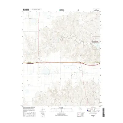
2016 Map of Jericho
USGS Topo · Published 2016About this map
Jericho sits on the high plains of the Texas Panhandle along the border of Gray and Donley Counties. This landscape is defined by the dramatic transition from the flat agricultural tablelands into the canyon systems formed by the drainage of McClellan Creek and Big Sandy Creek. In the northeast, the McClellan Creek National Grassland surrounds Lake McClellan, protecting a riparian environment that contrasts sharply with the surrounding dry ranges. Local history is anchored by the Jericho Cemetery and the more remote Boydston Cemetery to the southwest. The map details a network of rural routes, including McCoy Country Road and FM 1321, which connect isolated homesteads and ranching tracts across the breaks. The terrain here is deeply incised by seasonal waterways like Apple Orchard Creek and Carroll Creek, illustrating the erosional patterns common to the Caprock region.
Find a feature on this map
27 named features on this map. Tap any name to fly to it.
Don’t see what you’re looking for? This feature index may not catch every label — zoom into the map to look around manually.
Map Details
Editions of this 2016 Jericho Map
This is the sole edition of this map. No revisions or reprints were ever made.
Other maps of this area

1954 · Amarillo
USGS Topo · 1:250,000

1958 · Amarillo
USGS Topo · 1:250,000

1960 · Groom
USGS Topo · 1:62,500

1962 · Roach Ranch
USGS Topo · 1:24,000

1962 · Griffin Ranch
USGS Topo · 1:24,000

1964 · Jericho
USGS Topo · 1:24,000

1964 · Rockledge
USGS Topo · 1:24,000

1966 · Grandview School
USGS Topo · 1:24,000

1968 · Taylor Ranch
USGS Topo · 1:24,000
1968 · Deep Lake
USGS Topo · 1:24,000