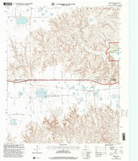
1998 Map of Jericho
USGS Topo · Published 2001About this map
Jericho sits as a quiet focal point in the Texas Panhandle, positioned just south of the Gray Co Donley Co Boundary. This area, updated in the late 1990s, reveals a landscape defined by the intersection of livestock grazing and the energy industry, with numerous Gas Wells and an Oil Well scattered across the undulating terrain. The McClellan Creek National Grassland dominates the northeast, providing a conserved natural space along McClellan Creek. Local heritage is anchored by the Jericho Cem and Boydston Cem, which serve as vital markers for genealogists and local historians tracing the early settlement of these high plains. Water resources are clearly a priority in this semi-arid region, evidenced by the multiple labeled Wells and the course of Sandy Creek to the south.
Find a feature on this map
14 named features on this map. Tap any name to fly to it.
Don’t see what you’re looking for? This feature index may not catch every label — zoom into the map to look around manually.
Map Details
Editions of this 1998 Jericho Map
This is the sole edition of this map. No revisions or reprints were ever made.
Other maps of this area

1954 · Amarillo
USGS Topo · 1:250,000

1958 · Amarillo
USGS Topo · 1:250,000

1960 · Groom
USGS Topo · 1:62,500

1962 · Roach Ranch
USGS Topo · 1:24,000

1962 · Griffin Ranch
USGS Topo · 1:24,000

1964 · Jericho
USGS Topo · 1:24,000

1964 · Rockledge
USGS Topo · 1:24,000

1966 · Grandview School
USGS Topo · 1:24,000

1968 · Taylor Ranch
USGS Topo · 1:24,000
1968 · Deep Lake
USGS Topo · 1:24,000