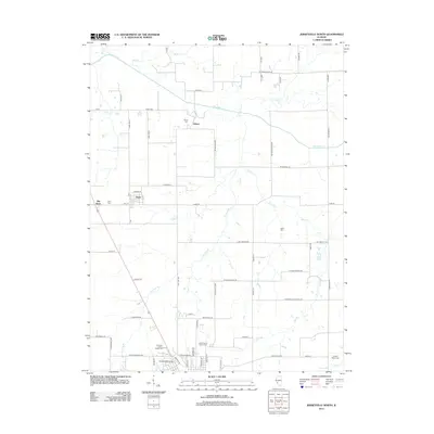
2012 Map of Jerseyville North
USGS Topo · Published 2012About this map
Macoupin Cr and its various tributaries, such as Phils Cr and Taylor Cr, snake through this rural Illinois landscape, defining the topography north of Jerseyville. The settlement of Kane serves as a primary hub, while the distinct labels for Old Kane and the small community of Jalapa further north offer a window into the historical development and shifting centers of local life. This 2012 survey provides a wealth of genealogical data, marking several family and community burial sites including Burch Cem, Keller Cem, and Saint Francis Xaviers Cem. The southern portion of the map transitions into more developed recreation and public spaces, featuring the American Legion Fairground and Westlake Golf Course near the town limits. Roadways such as Kane Rd and Co Hwy-21 connect these agricultural and residential zones across the county.
Find a feature on this map
61 named features on this map. Tap any name to fly to it.
Don’t see what you’re looking for? This feature index may not catch every label — zoom into the map to look around manually.
Map Details
Editions of this 2012 Jerseyville North Map
This is the sole edition of this map. No revisions or reprints were ever made.
Other maps of this area

1924 · Roodhouse
USGS Topo · 1:62,500

1925 · Brighton
USGS Topo · 1:62,500

1926 · Roodhouse
USGS Topo · 1:62,500

1928 · Brighton
USGS Topo · 1:62,500

1930 · Jerseyville
USGS Topo · 1:62,500

1932 · Greenfield
USGS Topo · 1:62,500

1933 · Jerseyville
USGS Topo · 1:62,500

1948 · Quincy
USGS Topo · 1:250,000

1956 · Quincy
USGS Topo · 1:250,000
1983 · Boyer Creek
USGS Topo · 1:24,000