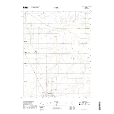
2018 Map of Jerseyville North
USGS Topo · Published 2018About this map
The agricultural landscape of northern Jersey County and southern Greene County is defined by the winding course of Macoupin Creek and its tributaries, including Phils Cr and Sand Cr. The settlement of Kane stands as a central hub, while the distinction between it and Old Kane offers a glimpse into local development patterns. To the south, the city of Jerseyville transitions into a grid of rural roads and scattered homesteads. Genealogy interests are well-served by numerous burial sites throughout the townships, such as Saint Francis Xaviers Cem, Oak Grove Cem, and Keller Cem. The map documents a mature rural infrastructure, where named routes like Victory School Rd and Pleasant Hill School Rd trace the locations of former community landmarks. These features, along with small water bodies like Heild Pond, provide a detailed view of the regional geography as it existed in the late 2010s.
Find a feature on this map
68 named features on this map. Tap any name to fly to it.
Don’t see what you’re looking for? This feature index may not catch every label — zoom into the map to look around manually.
Map Details
Editions of this 2018 Jerseyville North Map
This is the sole edition of this map. No revisions or reprints were ever made.
Other maps of this area

1924 · Roodhouse
USGS Topo · 1:62,500

1925 · Brighton
USGS Topo · 1:62,500

1926 · Roodhouse
USGS Topo · 1:62,500

1928 · Brighton
USGS Topo · 1:62,500

1930 · Jerseyville
USGS Topo · 1:62,500

1932 · Greenfield
USGS Topo · 1:62,500

1933 · Jerseyville
USGS Topo · 1:62,500

1948 · Quincy
USGS Topo · 1:250,000

1956 · Quincy
USGS Topo · 1:250,000
1983 · Boyer Creek
USGS Topo · 1:24,000