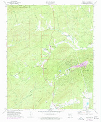
1972 Map of Jessieville
USGS Topo · Published 1977About this map
Jessieville serves as a central hub in this Garland County landscape, where the foothills of the Ouachita National Forest meet evolving residential developments. By the early 1970s, the emergence of Hot Springs Village and the creation of Lake DeSoto signaled a shift toward leisure and community planning near the older settlement of Mountain Valley. The map documents a spiritual and communal geography through numerous local landmarks, including Bethlehem Ch, Cedar Mountain Ch, and Glazier Peau Ch, alongside several family and community burial grounds like Shiloh Cem and Cosby Cem. The terrain is defined by the drainages of Blakely Creek and the Poison Fork Saline River, which cut between prominent elevations such as Short Mountain and Cedar Mountain, illustrating the intersection of timberland, early industry like the Mine near Little Blakely Creek, and new infrastructure.
Find a feature on this map
42 named features on this map. Tap any name to fly to it.
Don’t see what you’re looking for? This feature index may not catch every label — zoom into the map to look around manually.
Map Details
Editions of this 1972 Jessieville Map
2 editions found
Other maps of this area

1890 · Benton
USGS Topo · 1:125,000

1890 · Hot Springs
USGS Topo · 1:125,000

1894 · Hot Springs
USGS Topo · 1:125,000

1894 · Benton
USGS Topo · 1:125,000

1955 · Little Rock
USGS Topo · 1:250,000

1956 · Little Rock
USGS Topo · 1:250,000

1960 · Little Rock
USGS Topo · 1:250,000

1963 · Paron SW
USGS Topo · 1:24,000

1964 · Little Rock
USGS Topo · 1:250,000
1966 · Hot Springs North
USGS Topo · 1:24,000