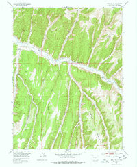
1952 Map of Jessup Gulch
USGS Topo · Published 1977About this map
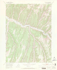
Piceance Creek meanders through the heart of this high-plateau landscape, serving as the primary corridor for agricultural settlement in the mid-20th century. The map illustrates a network of family-held properties along the valley floor, including the P-L Ranch, Redd Ranch, and the Walter Oldland Ranch. The presence of the Stewart School near the confluence of Stewart Gulch and the creek points to a localized community center for the surrounding ranching families. Beyond the narrow riparian zones, the terrain rises sharply into a series of dissected ridges and gulches, such as Barnes Ridge and Sorghum Gulch. The reliance on water management is evident through several marked Ditch segments and a Flume along the creek, showing how early residents adapted to the semi-arid conditions of Rio Blanco County before modern large-scale developments altered the ranching economy.
Find a feature on this map
34 named features on this map. Tap any name to fly to it.
Don’t see what you’re looking for? This feature index may not catch every label — zoom into the map to look around manually.
Map Details
Editions of this 1952 Jessup Gulch Map
6 editions found
Other maps of this area

1925 · Parachute Creek
USGS Topo · 1:62,500

1927 · Parachute Creek
USGS Topo · 1:62,500

1929 · Highmore
USGS Topo · 1:62,500

1952 · Rock School
USGS Topo · 1:24,000

1952 · Jessup Gulch
USGS Topo · 1:24,000

1952 · Greasewood Gulch
USGS Topo · 1:24,000

1952 · Square S Ranch
USGS Topo · 1:24,000

1952 · No Name Ridge
USGS Topo · 1:24,000

1952 · Segar Mountain
USGS Topo · 1:24,000

1956 · Grand Junction
USGS Topo · 1:250,000