
1969 Map of Jet SE
USGS Topo · Published 1971About this map
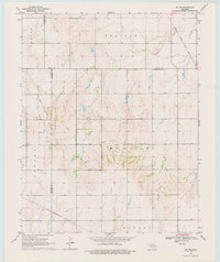
Atchison Topeka and Santa Fe and St Louis San Francisco railroad lines cross this section of the Oklahoma plains, marking the vital transportation corridors that shaped north-central Oklahoma. Surveyed in the late 1960s, the landscape is defined by its topographic townships including Prairie, McKinley, Karoma, Hobart, and Saline. The map reveals a rural economy transitioning from traditional agriculture to energy extraction, evidenced by an isolated Oil Well and a Radio Tower located near the Garfield and Alfalfa county lines. Drainage is primarily managed by Coldwater Creek, which meanders through the northeast corner, while a dense network of section-line roads provides a rigid grid for the occasional farmstead and agricultural operation.
Find a feature on this map
13 named features on this map. Tap any name to fly to it.
Don’t see what you’re looking for? This feature index may not catch every label — zoom into the map to look around manually.
Map Details
Editions of this 1969 Jet SE Map
2 editions found
Other maps of this area

1955 · Enid West
USGS Topo · 1:24,000

1955 · Enid
USGS Topo · 1:250,000

1955 · Woodward
USGS Topo · 1:250,000

1956 · Enid
USGS Topo · 1:62,500

1956 · Ringwood
USGS Topo · 1:62,500

1958 · Enid
USGS Topo · 1:250,000

1958 · Woodward
USGS Topo · 1:250,000

1968 · Hillsdale
USGS Topo · 1:24,000

1968 · Pond Creek NW
USGS Topo · 1:24,000

1969 · Jet
USGS Topo · 1:24,000