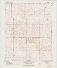
1969 Map of Jet SE
USGS Topo · Published 1977About this map
Prairie and McKinley townships define the open, agricultural character of north-central Oklahoma at the close of the 1960s. This survey, conducted just as regional transport patterns were maturing, illustrates a landscape divided by the intersection of major rail lines and county boundaries. The Atchison Topeka and Santa Fe railroad cuts across the northeast corner near Coldwater Creek, while the St Louis San Francisco line traverses the southern reaches. Evidence of the region's petroleum industry is visible through the presence of an Oil Well, highlighting the economic drivers of the era. Surveyed during the 1960s, the map provides a precise look at the section lines and rural infrastructure across Hobart and Karoma, documenting the sparse but essential landmarks of the high plains like a lone Radio Tower.
Find a feature on this map
12 named features on this map. Tap any name to fly to it.
Don’t see what you’re looking for? This feature index may not catch every label — zoom into the map to look around manually.
Map Details
Editions of this 1969 Jet SE Map
2 editions found

Other maps of this area

1955 · Enid West
USGS Topo · 1:24,000

1955 · Enid
USGS Topo · 1:250,000

1955 · Woodward
USGS Topo · 1:250,000

1956 · Enid
USGS Topo · 1:62,500

1956 · Ringwood
USGS Topo · 1:62,500

1958 · Enid
USGS Topo · 1:250,000

1958 · Woodward
USGS Topo · 1:250,000

1968 · Hillsdale
USGS Topo · 1:24,000

1968 · Pond Creek NW
USGS Topo · 1:24,000

1969 · Jet
USGS Topo · 1:24,000