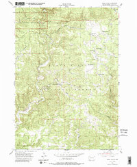
1955 Map of Jewel Cave
USGS Topo · Published 1988About this map
Jewel Cave National Monument anchors the northwestern corner of this mid-century survey, detailing the surface topography above the subterranean chambers of Jewel Cave. Set within the Black Hills National Forest, the landscape is defined by deep drainages like Hell Canyon and Lithograph Canyon, punctuated by high-altitude springs such as Lithograph Spring and McKenna Spring. This era reveals a pastoral economy of dispersed ranching, where family-named holdings like Wolf Ranch, Morrison Ranch, and Dunbar Ranch are connected by unimproved roads. Educational and industrial footprints are preserved here, including the remote Bull Flats Sch and small-scale resource extraction sites like the King Tut Mine and Stage Quarry. This document provides a record of the Custer County backcountry before modern road improvements and intensified tourism altered the rural character of the Black Hills.
Find a feature on this map
26 named features on this map. Tap any name to fly to it.
Don’t see what you’re looking for? This feature index may not catch every label — zoom into the map to look around manually.
Map Details
Editions of this 1955 Jewel Cave Map
3 editions found
Other maps of this area

1896 · Harney Peak
USGS Topo · 1:125,000

1901 · Harney Peak
USGS Topo · 1:125,000

1954 · Fourmile
USGS Topo · 1:24,000

1954 · Berne
USGS Topo · 1:24,000

1954 · Jewel Cave SE
USGS Topo · 1:24,000
1954 · Jewel Cave SW
USGS Topo · 1:24,000

1955 · Dead Horse Flats
USGS Topo · 1:24,000

1955 · Jewel Cave NW
USGS Topo · 1:24,000

1955 · Jewel Cave
USGS Topo · 1:24,000
1955 · Argyle
USGS Topo · 1:24,000