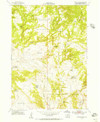
1954 Map of Jewel Cave SE
USGS Topo · Published 1956About this map
The Black Hills National Forest dominates this mid-century survey, revealing a landscape defined by isolated water sources and early educational infrastructure in Custer County. The presence of McClelland Sch and the evocative Rogers Shack Spring suggests a pattern of life centered on scattered springs and seasonal drainage points. Water management is a central theme, evidenced by features such as Richardson Well, Issue Wood Spring, and Richardson Spring.
Find a feature on this map
19 named features on this map. Tap any name to fly to it.
Don’t see what you’re looking for? This feature index may not catch every label — zoom into the map to look around manually.
Map Details
Editions of this 1954 Jewel Cave SE Map
4 editions found
Other maps of this area

1896 · Harney Peak
USGS Topo · 1:125,000

1901 · Harney Peak
USGS Topo · 1:125,000

1902 · Edgemont
USGS Topo · 1:125,000

1950 · Burdock
USGS Topo · 1:24,000

1950 · Edgemont NE
USGS Topo · 1:24,000

1950 · Minnekahta
USGS Topo · 1:24,000

1954 · Fourmile
USGS Topo · 1:24,000

1954 · Jewel Cave SE
USGS Topo · 1:24,000
1954 · Jewel Cave SW
USGS Topo · 1:24,000

1955 · Jewel Cave NW
USGS Topo · 1:24,000