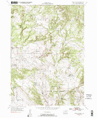
1954 Map of Jewel Cave SE
USGS Topo · Published 1991About this map
The Black Hills National Forest defines this Custer County landscape, where the deeply incised drainage of Hell Canyon meets a complex network of seasonal creeks and springs. Situated in the southwestern corner of the forest, the area is characterized by the convergence of Pass Creek, East Pass Creek, and West Pass Creek. Local infrastructure in the mid-1950s was sparse, centered around cattle ranching and forestry needs, as evidenced by the McClelland Sch and numerous named water sources such as Sutherland Spring and Rogers Shack Spring. The map's production involved the United States Atomic Energy Commission, reflecting the era's focus on mineral potential in the Black Hills. The absence of major settlements highlights the rural character of these limestone canyons and high ridges during the post-war period.
Find a feature on this map
17 named features on this map. Tap any name to fly to it.
Don’t see what you’re looking for? This feature index may not catch every label — zoom into the map to look around manually.
Map Details
Editions of this 1954 Jewel Cave SE Map
4 editions found
Other maps of this area

1896 · Harney Peak
USGS Topo · 1:125,000

1901 · Harney Peak
USGS Topo · 1:125,000

1902 · Edgemont
USGS Topo · 1:125,000

1950 · Burdock
USGS Topo · 1:24,000

1950 · Edgemont NE
USGS Topo · 1:24,000

1950 · Minnekahta
USGS Topo · 1:24,000

1954 · Fourmile
USGS Topo · 1:24,000

1954 · Jewel Cave SE
USGS Topo · 1:24,000
1954 · Jewel Cave SW
USGS Topo · 1:24,000

1955 · Jewel Cave NW
USGS Topo · 1:24,000