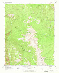
1964 Map of Jicarita Peak
USGS Topo · Published 1972About this map
Jicarita Peak and Little Jicarita Peak dominate this high-altitude landscape where the boundaries of Taos, Rio Arriba, and Mora counties meet. The area is defined by the convergence of the Carson and Santa Fe National Forests, centered on the Pecos Wilderness. A complex network of pack trails, including the Osha Trail and Comales Trail, provide the primary access through deep canyons like Comales Canyon and Osha Canyon.
Find a feature on this map
37 named features on this map. Tap any name to fly to it.
Don’t see what you’re looking for? This feature index may not catch every label — zoom into the map to look around manually.
Map Details
Editions of this 1964 Jicarita Peak Map
Other maps of this area

1889 · Las Vegas
USGS Topo · 1:125,000

1889 · Santa Fe
USGS Topo · 1:125,000

1891 · Las Vegas
USGS Topo · 1:125,000

1893 · Las Vegas
USGS Topo · 1:125,000

1894 · Santa Fe
USGS Topo · 1:125,000

1954 · Santa Fe
USGS Topo · 1:250,000

1954 · Raton
USGS Topo · 1:250,000

1958 · Raton
USGS Topo · 1:250,000

1958 · Santa Fe
USGS Topo · 1:250,000
1963 · Truchas Peak
USGS Topo · 1:24,000