
1959 Map of Jiggs
USGS Topo · Published 1960About this map
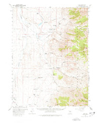
Huntington Valley and the western slopes of the Humboldt National Forest define this ranching landscape in late-1950s Elko County. The settlement of Jiggs serves as a central point for a network of established family ranching operations, including the Zunino Ranch, Hansel Ranch, and Sestenovich Ranch. This era shows a community deeply tied to its water sources, with the Smith Creek School situated near the confluence of Cottonwood Creek and Smith Creek. To the east, the terrain rises toward the Ruby Mountains, marked by the Harrison Pass Guard Sta near Harrison Pass. The map reveals the intricate water management of the high desert, documenting numerous Springs and the course of Huntington Creek through the valley floor. Small-scale exploration is evident in the foothills with several Prospects and Tunnels mapped near the forest boundary.
Find a feature on this map
50 named features on this map. Tap any name to fly to it.
Don’t see what you’re looking for? This feature index may not catch every label — zoom into the map to look around manually.
Map Details
Editions of this 1959 Jiggs Map
2 editions found
Other maps of this area

1934 · Jiggs
USGS Topo · 1:125,000

1935 · Halleck
USGS Topo · 1:125,000

1937 · Jiggs
USGS Topo · 1:125,000

1952 · Dixie Flats
USGS Topo · 1:62,500

1955 · Elko
USGS Topo · 1:250,000

1956 · Robinson Mtn
USGS Topo · 1:62,500

1958 · Elko
USGS Topo · 1:250,000

1959 · Railroad Pass
USGS Topo · 1:62,500

1959 · Sherman Mtn
USGS Topo · 1:62,500

1962 · Elko
USGS Topo · 1:250,000