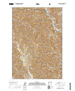
2020 Map of Jim Creek Butte
USGS Topo · Published 2020About this map
The Snake Wild and Scenic River carves a deep boundary along the eastern edge of this terrain, where Idaho, Oregon, and Washington converge. This landscape is defined by the steep elevation changes of the Wallowa National Forest, descending from heights like Mt Wilson and Jim Creek Butte toward the river's edge. Navigational challenges along the water are noted by several named whitewater features, including McDuff Rapids, Lower Cache Creek Rapids, and Cougar Rapids.
Find a feature on this map
91 named features on this map. Tap any name to fly to it.
Don’t see what you’re looking for? This feature index may not catch every label — zoom into the map to look around manually.
Map Details
Editions of this 2020 Jim Creek Butte Map
This is the sole edition of this map. No revisions or reprints were ever made.
Other maps of this area

1944 · Anatone
USGS Topo · 1:62,500

1946 · Limekiln Rapids
USGS Topo · 1:62,500

1946 · Anatone
USGS Topo · 1:62,500

1955 · Pullman
USGS Topo · 1:250,000

1955 · Grangeville
USGS Topo · 1:250,000

1958 · Pullman
USGS Topo · 1:250,000

1959 · Grangeville
USGS Topo · 1:250,000

1963 · Deadhorse Ridge
USGS Topo · 1:24,000

1963 · Jim Creek Butte
USGS Topo · 1:24,000

1963 · Wapshilla Creek
USGS Topo · 1:24,000