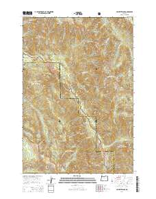
2014 Map of Jim White Ridge
USGS Topo · Published 2014About this map
The Minam River flows through the center of this high-country landscape, marking the boundary between Union Co and Wallowa Co. The topography is dominated by dramatic ridges and basins, including the namesake Jim White Ridge and the expansive Lake Basin near the northern edge. A notable point of human activity is the Reds Wallowa Horse Ranch Airport, a backcountry airstrip serving the remote reaches of the Wallowa National Forest. The map also captures several natural landmarks such as Minam Falls and the Big Burn, which speak to the environmental history and hydrological features of the Eagle Cap area. Various tributaries like Whoopee Cr and Threemile Cr feed into the river systems, illustrating a complex drainage pattern across Whitman National Forest.
Find a feature on this map
42 named features on this map. Tap any name to fly to it.
Don’t see what you’re looking for? This feature index may not catch every label — zoom into the map to look around manually.
Map Details
Editions of this 2014 Jim White Ridge Map
This is the sole edition of this map. No revisions or reprints were ever made.
Other maps of this area

1906 · Telocaset
USGS Topo · 1:125,000

1954 · Eagle Cap
USGS Topo · 1:62,500

1955 · Grangeville
USGS Topo · 1:250,000

1957 · Enterprise
USGS Topo · 1:62,500

1959 · Grangeville
USGS Topo · 1:250,000

1965 · China Cap
USGS Topo · 1:24,000

1965 · Fox Point
USGS Topo · 1:24,000
1965 · Mount Moriah
USGS Topo · 1:24,000

1965 · Little Catherine Creek
USGS Topo · 1:24,000
1965 · Mt. Fanny
USGS Topo · 1:24,000