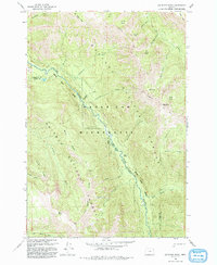
1993 Map of Jim White Ridge
USGS Topo · Published 1993About this map
Jim White Ridge anchors this portion of the Wallowa-Whitman National Forest in northeast Oregon, where high-altitude basins and drainage networks define the terrain. The landscape is marked by the Eagle Cap Wilderness and the deep incision of the Minam River as it flows northwest. Historical land use and environmental events are visible through features like the Big Burn and a remote Landing Strip in the northwest corner, likely supporting forest management or backcountry access. A complex network of Pack Trails provides the primary infrastructure through the high country, connecting locations like Corral Basin, Lake Basin, and Saddle Basin. The map also captures the intricate water system feeding the river, including North Fork Minam River and numerous high-elevation springs like Mud Spring, which serve as vital water sources in this steep, forested environment.
Find a feature on this map
41 named features on this map. Tap any name to fly to it.
Don’t see what you’re looking for? This feature index may not catch every label — zoom into the map to look around manually.
Map Details
Editions of this 1993 Jim White Ridge Map
This is the sole edition of this map. No revisions or reprints were ever made.
Other maps of this area

1906 · Telocaset
USGS Topo · 1:125,000

1954 · Eagle Cap
USGS Topo · 1:62,500

1955 · Grangeville
USGS Topo · 1:250,000

1957 · Enterprise
USGS Topo · 1:62,500

1959 · Grangeville
USGS Topo · 1:250,000

1965 · China Cap
USGS Topo · 1:24,000

1965 · Fox Point
USGS Topo · 1:24,000
1965 · Mount Moriah
USGS Topo · 1:24,000

1965 · Little Catherine Creek
USGS Topo · 1:24,000
1965 · Mt. Fanny
USGS Topo · 1:24,000