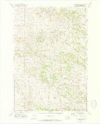
1971 Map of John Hen Creek
USGS Topo · Published 1974About this map
Gobblers Knob rises as a prominent landmark in this drainage-heavy landscape of eastern Montana, where the terrain is defined by a dense network of coulees and seasonal waterways. Surveyed in the early 1970s, the map reveals a remote ranching or resource extraction environment characterized by numerous water features including John Hen Creek, Cherry Creek, and Cottonwood Creek. The presence of scattered wells and a Drill Hole indicates subsurface exploration or water management in this arid stretch of Rosebud County. The map captures a moment when few improved roads reached these hills, instead relying on routes like the labeled Trail and unnamed fence-line tracks to navigate between the drainages of Dry Creek and Snider Creek.
Find a feature on this map
10 named features on this map. Tap any name to fly to it.
Don’t see what you’re looking for? This feature index may not catch every label — zoom into the map to look around manually.
Map Details
Editions of this 1971 John Hen Creek Map
This is the sole edition of this map. No revisions or reprints were ever made.
Other maps of this area

1954 · Hardin
USGS Topo · 1:250,000

1954 · Forsyth
USGS Topo · 1:250,000

1957 · Hardin
USGS Topo · 1:250,000

1957 · Forsyth
USGS Topo · 1:250,000

1958 · Forsyth
USGS Topo · 1:250,000

1958 · Hardin
USGS Topo · 1:250,000
1969 · Miller Creek SW
USGS Topo · 1:24,000
1971 · Brandenberg NW
USGS Topo · 1:24,000

1971 · Hammond Draw NW
USGS Topo · 1:24,000

1971 · Hammond Draw
USGS Topo · 1:24,000