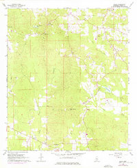
1968 Map of Johns
USGS Topo · Published 1976About this map
The community of Johns serves as a focal point for this rural landscape in central Mississippi, characterized by a network of creek drainages and small-scale agriculture. This 1968 survey, photorevised in 1975, documents the area just as local infrastructure began to modernize, evidenced by the inclusion of the Shiloh Lookout Tower and multiple church communities that anchored the social life of the region. Scattered throughout the hills are landmarks of local significance, such as the Indian Mound Hill and several small rural cemeteries, including Johns Cem. The drainage patterns of Dabbs Creek, Campbell Creek, and Clear Creek define the topography, while small impoundments like Corr-Williams Lake and Diamond D Lake show the adaptation of the land for water management. The presence of a Gravel Pit and various other pits suggests localized resource extraction alongside the primary timber and farming activities of the era.
Find a feature on this map
21 named features on this map. Tap any name to fly to it.
Don’t see what you’re looking for? This feature index may not catch every label — zoom into the map to look around manually.
Map Details
Editions of this 1968 Johns Map
3 editions found

Other maps of this area

1922 · Morton
USGS Topo · 1:48,000

1922 · Pelahatchee
USGS Topo · 1:48,000

1924 · Pelahatchee
USGS Topo · 1:62,500

1924 · Morton
USGS Topo · 1:62,500

1935 · White Oak
USGS Topo · 1:24,000

1950 · Pelahatchie
USGS Topo · 1:62,500

1951 · Morton
USGS Topo · 1:62,500

1952 · Pelahatchie
USGS Topo · 1:62,500

1953 · Meridian
USGS Topo · 1:250,000

1957 · Meridian
USGS Topo · 1:250,000