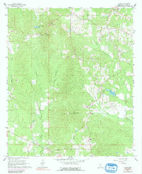
1968 Map of Johns
USGS Topo · Published 1991About this map
Johns sits at the southern edge of this Mississippi landscape, serving as a focal point for rural life in Rankin County during the late 1960s. The area is defined by a network of creeks, including Campbell Creek, Dobbs Creek, and Clear Creek, which carve through the wooded terrain. Cultural landmarks are scattered throughout the quadrangle, with Shiloh Ch and the nearby Shiloh Lookout Tower marking a high point in the north, while Mountain Ridge Ch and Cross Roads Ch anchor other local communities.
Find a feature on this map
21 named features on this map. Tap any name to fly to it.
Don’t see what you’re looking for? This feature index may not catch every label — zoom into the map to look around manually.
Map Details
Editions of this 1968 Johns Map
3 editions found

Other maps of this area

1922 · Morton
USGS Topo · 1:48,000

1922 · Pelahatchee
USGS Topo · 1:48,000

1924 · Pelahatchee
USGS Topo · 1:62,500

1924 · Morton
USGS Topo · 1:62,500

1935 · White Oak
USGS Topo · 1:24,000

1950 · Pelahatchie
USGS Topo · 1:62,500

1951 · Morton
USGS Topo · 1:62,500

1952 · Pelahatchie
USGS Topo · 1:62,500

1953 · Meridian
USGS Topo · 1:250,000

1957 · Meridian
USGS Topo · 1:250,000