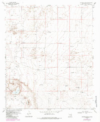
1970 Map of Johnson Ranch
USGS Topo · Published 1985About this map
The Johnson Ranch and the surrounding high plains of Lea County are defined by a network of ranching infrastructure and petroleum extraction. Located within the Inbe Oil Field, the landscape is dotted with numerous Oil Wells and Gravel Pits, illustrating the industrial activity of the late 1960s and early 1970s. Water management is central to life in this arid region, evidenced by a dense distribution of named water sources such as the Sand Windmill, Lucky Windmill, and Jog Windmill. To the south, the terrain descends into the Simanola Valley, where the Four Lakes Area provides a distinct geographic contrast. This area includes North Lake, East Lake, and Middle Lake, which serve as critical landmarks amidst the oil-producing flats. Notable livestock features like the X-4 Corral and X-4 Windmill further highlight the dual-purpose nature of this New Mexico territory during this era.
Find a feature on this map
24 named features on this map. Tap any name to fly to it.
Don’t see what you’re looking for? This feature index may not catch every label — zoom into the map to look around manually.
Map Details
Editions of this 1970 Johnson Ranch Map
2 editions found
Other maps of this area

1954 · Brownfield
USGS Topo · 1:250,000

1958 · Brownfield
USGS Topo · 1:250,000

1961 · Johnson Ranch
USGS Topo · 1:24,000

1962 · Brownfield
USGS Topo · 1:250,000

1970 · Johnson Ranch
USGS Topo · 1:24,000

1970 · Simanola Valley
USGS Topo · 1:24,000

1970 · Ranger Lake
USGS Topo · 1:24,000

1970 · Tatum North
USGS Topo · 1:24,000

1972 · Milnesand SW
USGS Topo · 1:24,000

1972 · Crossroads
USGS Topo · 1:24,000