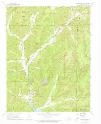
1968 Map of Johnson Shut-Ins
USGS Topo · Published 1973About this map
The rugged topography of the St. Francois Mountains is clearly defined in this late 1960s study, anchored by the Johnson Shut-Ins State Park along the East Fork Black River. This era captures a significant industrial transformation in the landscape, notably the presence of the Taum Sauk Pumped Storage Hydroelectric Powerplant and its associated Upper Reservoir atop Proffit Mountain. The map serves as a vital record for genealogists, preserving the locations of family-named landmarks like Chapman Cem and Hasty Cem, alongside rural congregations at New Hope Ch and Marys Chapel. Beyond the hydro-power infrastructure, evidence of older extractive industries remains at the Kaolin mine and a local Quarry, while the Taum Sauk Trail winds through the Clark National Forest, illustrating the region's dual identity as a site of both intensive utility and preserved wilderness.
Find a feature on this map
37 named features on this map. Tap any name to fly to it.
Don’t see what you’re looking for? This feature index may not catch every label — zoom into the map to look around manually.
Map Details
Editions of this 1968 Johnson Shut-Ins Map
4 editions found
Other maps of this area

1924 · Edgehill
USGS Topo · 1:62,500

1926 · Edgehill
USGS Topo · 1:62,500

1926 · Des Arc
USGS Topo · 1:62,500

1929 · Des Arc
USGS Topo · 1:62,500

1937 · Ironton
USGS Topo · 1:48,000

1943 · Lesterville
USGS Topo · 1:62,500

1945 · Ironton
USGS Topo · 1:62,500

1946 · Lesterville
USGS Topo · 1:62,500

1946 · Ironton
USGS Topo · 1:62,500

1949 · Rolla
USGS Topo · 1:250,000