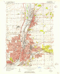
1954 Map of Joliet
USGS Topo · Published 1955About this map
The Des Plaines River corridor and the Ship Canal dominate this industrial landscape during the mid-1950s, defining the development of Joliet and Lockport. The heavy presence of institutional and industrial sites is clear, from the Stateville State Prison and Quarry State Prison to the massive Oil Refinery and numerous quarries. The era's transportation network is densely detailed, featuring the Elgin Joliet and Eastern Railroad and the Gulf Mobile and Ohio Railroad alongside the historic Lincoln Highway.
Find a feature on this map
93 named features on this map. Tap any name to fly to it.
Don’t see what you’re looking for? This feature index may not catch every label — zoom into the map to look around manually.
Map Details
Editions of this 1954 Joliet Map
This is the sole edition of this map. No revisions or reprints were ever made.
Other maps of this area

1890 · Des Plaines
USGS Topo · 1:62,500

1892 · Joliet
USGS Topo · 1:62,500

1892 · Wilmington
USGS Topo · 1:62,500

1894 · Des Plaines
USGS Topo · 1:62,500

1900 · Des Plaines
USGS Topo · 1:62,500

1901 · Des Plaines
USGS Topo · 1:62,500

1918 · Wilmington
USGS Topo · 1:62,500

1923 · Joliet
USGS Topo · 1:62,500

1928 · Sag Bridge
USGS Topo · 1:24,000
1929 · Brisbane
USGS Topo · 1:24,000