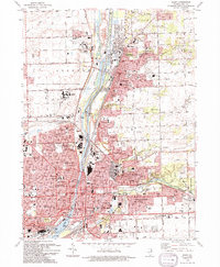
1993 Map of Joliet
USGS Topo · Published 1994About this map
The industrial and institutional heart of northern Illinois is centered here along the Des Plaines River and the Sanitary and Ship Canal. This landscape is defined by its massive correctional facilities, including the Stateville Correctional Center and the Joliet State Correctional Ctr, alongside the intensive infrastructure of the Lockport Locks and a large Oil Refinery. The dense residential grids of Joliet, Lockport, and Crest Hill are interspersed with significant local landmarks like Lewis College and the village of Lidice. Genealogists will find a wealth of records in the numerous burial grounds, such as Mt Olivet Cemetery, Mt Calvary Cem, and the Russian Cem. This document records the intricate overlap of heavy transit, including the Chicago and North Western line, and the established community centers of Rockdale and South Lockport.
Find a feature on this map
138 named features on this map. Tap any name to fly to it.
Don’t see what you’re looking for? This feature index may not catch every label — zoom into the map to look around manually.
Map Details
Editions of this 1993 Joliet Map
This is the sole edition of this map. No revisions or reprints were ever made.
Other maps of this area

1890 · Des Plaines
USGS Topo · 1:62,500

1892 · Joliet
USGS Topo · 1:62,500

1892 · Wilmington
USGS Topo · 1:62,500

1894 · Des Plaines
USGS Topo · 1:62,500

1900 · Des Plaines
USGS Topo · 1:62,500

1901 · Des Plaines
USGS Topo · 1:62,500

1918 · Wilmington
USGS Topo · 1:62,500

1923 · Joliet
USGS Topo · 1:62,500

1928 · Sag Bridge
USGS Topo · 1:24,000

1929 · Brisbane
USGS Topo · 1:24,000