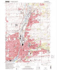
1998 Map of Joliet
USGS Topo · Published 2001About this map
The Des Plaines River corridor serves as the industrial and transportation backbone of this region, home to the sprawling Joliet Steel Works (State Historic Site) and the heavy infrastructure of the Brandon Locks. The map captures the dense residential and institutional development of the late 20th century, including the massive Stateville Correctional Center and the Joliet State Correctional Ctr.
Find a feature on this map
78 named features on this map. Tap any name to fly to it.
Don’t see what you’re looking for? This feature index may not catch every label — zoom into the map to look around manually.
Map Details
Editions of this 1998 Joliet Map
This is the sole edition of this map. No revisions or reprints were ever made.
Other maps of this area

1890 · Des Plaines
USGS Topo · 1:62,500

1892 · Joliet
USGS Topo · 1:62,500

1892 · Wilmington
USGS Topo · 1:62,500

1894 · Des Plaines
USGS Topo · 1:62,500

1900 · Des Plaines
USGS Topo · 1:62,500

1901 · Des Plaines
USGS Topo · 1:62,500

1918 · Wilmington
USGS Topo · 1:62,500

1923 · Joliet
USGS Topo · 1:62,500

1928 · Sag Bridge
USGS Topo · 1:24,000

1929 · Brisbane
USGS Topo · 1:24,000