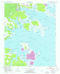
1950 Map of Jones Bay
USGS Topo · Published 1977About this map
Hobucken serves as a primary settlement point on this coastal landscape, situated near the north edge of the Intracoastal Waterway. The map illustrates a region dominated by intricate wetlands and tidal waters, notably the expansive Gum Swamp and the Goose Creek State Game Refuge. A fascinating relic of local industry or timbering is visible in the form of a Tramway Abandoned crossing the marshlands near Drum Creek. Along the shores of Jones Bay and the Neuse River, numerous family-named points and shoals like Bryan Point and Maw Point define the navigation of these waters. The presence of the US Coast Guard Reservation underscores the maritime importance of this transition point between the Sound and the river system. Local infrastructure is evidenced by the small Cem near the village and waterfront locations like Bills Creek Landing, hinting at a long-standing reliance on the local creek networks for transit and trade.
Find a feature on this map
113 named features on this map. Tap any name to fly to it.
Don’t see what you’re looking for? This feature index may not catch every label — zoom into the map to look around manually.
Map Details
Editions of this 1950 Jones Bay Map
4 editions found
Other maps of this area

1948 · Oriental
USGS Topo · 1:24,000

1949 · Point Of Marsh
USGS Topo · 1:24,000

1950 · Point Of Marsh
USGS Topo · 1:24,000

1950 · Vandemere
USGS Topo · 1:24,000

1950 · Lowland
USGS Topo · 1:24,000

1950 · South Creek
USGS Topo · 1:24,000

1950 · Jones Bay
USGS Topo · 1:24,000

1951 · Brant Island
USGS Topo · 1:24,000

1951 · Broad Creek
USGS Topo · 1:24,000

1951 · Pamlico Point
USGS Topo · 1:24,000