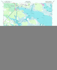
1950 Map of Jones Bay
USGS Topo · Published 1993About this map
Hobucken anchors the northern reaches of this coastal landscape, situated where the Intracoastal Waterway cuts through the lowlands near Goose Creek. This mid-century survey reveals a shoreline defined by intricate maritime geography, from the marshes of Gum Swamp to the expansive waters of Jones Bay. An Abandoned Tramway provides a tangible link to former timber or industrial activity, tracing a path south of Goose Creek State Game Land. Along the fragmented coast, family and descriptive landmarks like Bills Creek Landing, Persimmon Tree Point, and Deadman Point indicate the localized nature of navigation and settlement. The map captures the area before significant modern development, showing the complex system of creeks like Gale Creek and Chadwick Creek that served as the primary arteries for this water-dependent community.
Find a feature on this map
108 named features on this map. Tap any name to fly to it.
Don’t see what you’re looking for? This feature index may not catch every label — zoom into the map to look around manually.
Map Details
Editions of this 1950 Jones Bay Map
4 editions found
Other maps of this area

1948 · Oriental
USGS Topo · 1:24,000

1949 · Point Of Marsh
USGS Topo · 1:24,000

1950 · Point Of Marsh
USGS Topo · 1:24,000

1950 · Vandemere
USGS Topo · 1:24,000

1950 · Lowland
USGS Topo · 1:24,000

1950 · South Creek
USGS Topo · 1:24,000

1950 · Jones Bay
USGS Topo · 1:24,000

1951 · Brant Island
USGS Topo · 1:24,000

1951 · Broad Creek
USGS Topo · 1:24,000

1951 · Pamlico Point
USGS Topo · 1:24,000