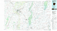
1986 Map of Jonesboro
USGS Topo · Published 1986About this map
Crowley's Ridge dominates the central topography of this Northeast Arkansas landscape, providing a narrow elevated spine through the surrounding lowlands of the Mississippi Alluvial Plain. In the mid-1980s, Jonesboro serves as the primary regional hub, where the St Louis Southwestern Railway and Burlington Northern Railroad intersect to define the city's transport layout. The eastern half of the map reveals an intricate hydraulic environment, featuring the Oak Donnick Floodway and the St Francis Sunken Lands State Wildlife Management Area, illustrating the complex drainage and conservation efforts of the St. Francis Basin.
Find a feature on this map
148 named features on this map. Tap any name to fly to it.
Don’t see what you’re looking for? This feature index may not catch every label — zoom into the map to look around manually.
Map Details
Editions of this 1986 Jonesboro Map
2 editions found
Other maps of this area

1931 · Jericho
USGS Topo · 1:62,500

1932 · Walnut Ridge
USGS Topo · 1:62,500

1934 · Kennett
USGS Topo · 1:62,500

1934 · Powhatan
USGS Topo · 1:62,500

1935 · Powhatan
USGS Topo · 1:62,500

1935 · Sedgwick
USGS Topo · 1:62,500

1935 · Alicia
USGS Topo · 1:62,500

1935 · Tuckerman
USGS Topo · 1:62,500

1935 · Walnut Ridge
USGS Topo · 1:62,500

1939 · Vanndale
USGS Topo · 1:62,500