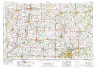
1954 Map of Joplin
USGS Topo · Published 1975About this map
The Kansas Army Ammunition Plant and the sprawling industrial activity of the Tri-State Mining District anchor this mid-century landscape. Following the 1974 revision of earlier surveys, the region reflects an era of intense resource extraction and military production along the borders of Missouri, Kansas, and Oklahoma. Numerous Strip mine operations are marked throughout Cherokee and Jasper counties, while the rail networks of the Missouri Pacific RR, St Louis-San Francisco RR, and the Kansas City Southern RR facilitate the movement of coal and lead through hubs like Joplin and Carthage. Notable terrain features such as the Bender Mounds and Guthrie Mountain rise above the river valleys of the Spring River and Neosho River, providing orientation in a landscape increasingly defined by highway expansion and industrial sites.
Find a feature on this map
261 named features on this map. Tap any name to fly to it.
Don’t see what you’re looking for? This feature index may not catch every label — zoom into the map to look around manually.
Map Details
Editions of this 1954 Joplin Map

Other maps of this area

1884 · Fort Scott
USGS Topo · 1:125,000

1885 · Burlington
USGS Topo · 1:125,000

1885 · Eureka
USGS Topo · 1:125,000

1885 · Garnett
USGS Topo · 1:125,000

1885 · Sedan
USGS Topo · 1:125,000

1886 · Nevada
USGS Topo · 1:125,000

1886 · Fredonia
USGS Topo · 1:125,000

1886 · Joplin
USGS Topo · 1:125,000

1886 · Stockton
USGS Topo · 1:125,000

1886 · Greenfield
USGS Topo · 1:125,000