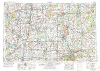
1954 Map of Joplin
USGS Topo · Published 1975About this map
Joplin and the surrounding tri-state border region are captured during a mid-century period of established rail infrastructure and significant river management. The landscape is defined by the Neosho River and Spring River, which supported the industrial growth of regional centers like Webb City and Galena. This 1970s revision of earlier 1950s data highlights a transition toward modern water control, shown by the presence of Stockton Lake and Pomme de Terre Lake.
Find a feature on this map
273 named features on this map. Tap any name to fly to it.
Don’t see what you’re looking for? This feature index may not catch every label — zoom into the map to look around manually.
Map Details
Editions of this 1954 Joplin Map

Other maps of this area

1884 · Fort Scott
USGS Topo · 1:125,000

1885 · Burlington
USGS Topo · 1:125,000

1885 · Eureka
USGS Topo · 1:125,000

1885 · Garnett
USGS Topo · 1:125,000

1885 · Sedan
USGS Topo · 1:125,000

1886 · Nevada
USGS Topo · 1:125,000

1886 · Fredonia
USGS Topo · 1:125,000

1886 · Joplin
USGS Topo · 1:125,000

1886 · Stockton
USGS Topo · 1:125,000

1886 · Greenfield
USGS Topo · 1:125,000