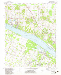
1982 Map of Joppa
USGS Topo · Published 1983About this map
The Ohio River shoreline defines this borderland between Illinois and Kentucky, dominated by heavy industry and large-scale conservation efforts. On the Illinois bank, the village of Joppa is characterized by extensive infrastructure, including a Powerplant, massive conveyors, and a Pumping Station. Across the water in Kentucky, the massive Shawnee Steam Plant (TVA) and the Energy Research and Development Administration (Paducah Plant) reflect the region's mid-century role in power generation and nuclear development.
Find a feature on this map
65 named features on this map. Tap any name to fly to it.
Don’t see what you’re looking for? This feature index may not catch every label — zoom into the map to look around manually.
Map Details
Editions of this 1982 Joppa Map
This is the sole edition of this map. No revisions or reprints were ever made.
Other maps of this area

1917 · Brownfield
USGS Topo · 1:62,500

1918 · Vienna
USGS Topo · 1:62,500

1919 · Vienna
USGS Topo · 1:62,500

1926 · Paducah
USGS Topo · 1:62,500

1928 · La Center
USGS Topo · 1:62,500

1929 · Paducah
USGS Topo · 1:62,500

1932 · La Center
USGS Topo · 1:62,500

1940 · Paducah
USGS Topo · 1:62,500

1942 · Vienna
USGS Topo · 1:62,500

1949 · Paducah
USGS Topo · 1:250,000