
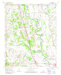
1965 Map of Joy
USGS Topo · Published 1966About this map
Fort Arbuckle Ruins stands as a significant historical marker in this 1960s landscape, positioned near the boundary where the Arbuckle Mountains meet the river plains. The terrain is defined by the winding course of the Washita River, which flows past the small settlements of Joy and Chigley. This era reveals a landscape heavily shaped by energy extraction, with the Northeast Butterly Oil Field, South Butterly Oil Field, and Turner Oil Field dotting the map with drilling pads and access roads.
Find a feature on this map
32 named features on this map. Tap any name to fly to it.
Don’t see what you’re looking for? This feature index may not catch every label — zoom into the map to look around manually.
Map Details
Editions of this 1965 Joy Map
2 editions found
Other maps of this area

1898 · Pauls Valley
USGS Topo · 1:125,000

1901 · Ardmore
USGS Topo · 1:125,000

1902 · Pauls Valley
USGS Topo · 1:125,000

1918 · Ardmore
USGS Topo · 1:125,000

1957 · Ardmore
USGS Topo · 1:250,000

1963 · Ardmore
USGS Topo · 1:250,000

1964 · Turner Falls
USGS Topo · 1:24,000

1965 · Pauls Valley NE
USGS Topo · 1:24,000

1965 · Pauls Valley
USGS Topo · 1:24,000

1965 · Davis
USGS Topo · 1:24,000