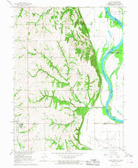
1966 Map of Julian
USGS Topo · Published 1968About this map
The Missouri River defines the eastern boundary of this mid-1960s survey, where the borders of Nebraska, Iowa, and Missouri meet amidst a landscape of shifting channels and river islands like Schemmel Island. The terrain transitions from the broad alluvial plains of Buchanan and Peru into the dissected uplands of Glen Rock and Otoe, where numerous small schools and churches served the rural population. In the village of Julian, the Pacific railroad line runs parallel to Rock Creek, while the Chicago Burlington and Quincy corridor follows the river bluffs further east.
Find a feature on this map
28 named features on this map. Tap any name to fly to it.
Don’t see what you’re looking for? This feature index may not catch every label — zoom into the map to look around manually.
Map Details
Editions of this 1966 Julian Map
2 editions found
Other maps of this area

1907 · Nebraska City
USGS Topo · 1:62,500

1915 · Nemaha
USGS Topo · 1:62,500

1915 · Howe
USGS Topo · 1:62,500

1939 · Hamburg
USGS Topo · 1:62,500

1939 · Nemaha
USGS Topo · 1:62,500

1941 · Hamburg
USGS Topo · 1:62,500

1949 · Nemaha
USGS Topo · 1:62,500

1955 · Nebraska City
USGS Topo · 1:250,000

1957 · Nebraska City
USGS Topo · 1:250,000

1958 · Nebraska City
USGS Topo · 1:250,000