
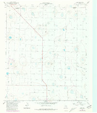
1966 Map of Jumbo
USGS Topo · Published 1968About this map
The High Plains of the Texas Panhandle define this 1960s landscape, where the rural settlement of Jumbo sits near the border of Deaf Smith Co Castro Co. The terrain is characterized by a high density of water wells and scattered depressions, suggesting the intense agricultural development of the Ogallala Aquifer during this era. A prominent Substation and a network of power lines and unimproved roads crisscross the grid-like section lines, reflecting the infrastructure required for large-scale irrigation and ranching. The natural drainage of Middle Tule Draw provides one of the few breaks in the plateau, winding through the eastern portion of the survey. The prominent high point at Lambert serves as a local landmark in an otherwise exceptionally flat expanse of the Llano Estacado.
Find a feature on this map
6 named features on this map. Tap any name to fly to it.
Don’t see what you’re looking for? This feature index may not catch every label — zoom into the map to look around manually.
Map Details
Editions of this 1966 Jumbo Map
2 editions found
Other maps of this area

1954 · Clovis
USGS Topo · 1:250,000

1958 · Clovis
USGS Topo · 1:250,000

1961 · Buffalo Lake
USGS Topo · 1:62,500

1965 · Dimmitt
USGS Topo · 1:24,000

1965 · Dimmitt SW
USGS Topo · 1:24,000

1965 · Nazareth SW
USGS Topo · 1:24,000

1966 · Nazareth NW
USGS Topo · 1:24,000

1966 · Easter
USGS Topo · 1:24,000

1970 · Hereford
USGS Topo · 1:24,000

1971 · Hereford SE
USGS Topo · 1:24,000