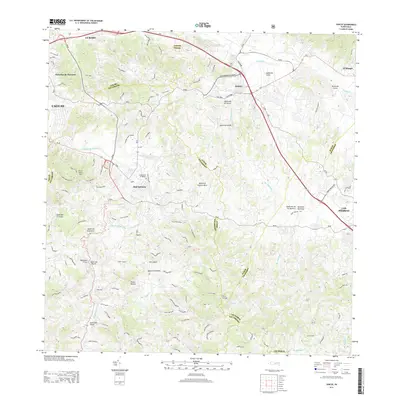
2013 Map of Juncos
USGS Topo · Published 2013About this map
The town of San Lorenzo and the municipality of Juncos anchor this survey of eastern Puerto Rico, showing a landscape defined by the intersection of mountain ridges and fertile river valleys. The Rio Grande De Loiza and the Rio Valenciano wind through the terrain, with numerous tributaries like Quebrada Salvatierra and Quebrada Grande dissecting the slopes of Cerro Santa Ana and Cerra Viviana. This 2013 data illustrates the modern road network, including PR-181 and PR-183, which connect the town centers to smaller settlements such as Parcelas de Navarro and El Mangó. Genealogists may find interest in the location of the Cementerio el Ramaso, while the detailed drainage patterns, including uniquely named features like Quebrada de los Muertos, provide a clear picture of the region's complex hydrology and land use.
Find a feature on this map
51 named features on this map. Tap any name to fly to it.
Don’t see what you’re looking for? This feature index may not catch every label — zoom into the map to look around manually.
Map Details
Editions of this 2013 Juncos Map
This is the sole edition of this map. No revisions or reprints were ever made.
Other maps of this area

1945 · El Yunque
USGS Topo · 1:30,000

1946 · Patillas
USGS Topo · 1:30,000

1946 · El Yunque
USGS Topo · 1:30,000

1946 · Aguas Buenas
USGS Topo · 1:30,000

1946 · Humacao
USGS Topo · 1:30,000

1946 · Punta Guayanes
USGS Topo · 1:30,000

1946 · Gurabo
USGS Topo · 1:30,000

1946 · Juncos
USGS Topo · 1:30,000

1946 · Yabucoa
USGS Topo · 1:30,000

1946 · Caguas
USGS Topo · 1:30,000