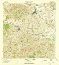
1958 Map of Juncos
USGS Topo · Published 1960About this map
Central Juncos stands as a focal point of industrial activity in this mid-century portrait of the eastern interior. The landscape is defined by the sharp transition from the valley floor of the Río Grande de Loíza to the steep, barrio-divided hillsides of Cerro Gordo and Mamey. The urban center of Juncos is shown in detail, flanked by the residential developments of Pueblo Norte and Pueblo Sur, while the nearby Planta de Tratamiento de Aguas Negras indicates the municipal infrastructure of the era.
Find a feature on this map
72 named features on this map. Tap any name to fly to it.
Don’t see what you’re looking for? This feature index may not catch every label — zoom into the map to look around manually.
Map Details
Editions of this 1958 Juncos Map
This is the sole edition of this map. No revisions or reprints were ever made.
Other maps of this area

1945 · El Yunque
USGS Topo · 1:30,000

1946 · Patillas
USGS Topo · 1:30,000

1946 · El Yunque
USGS Topo · 1:30,000

1946 · Aguas Buenas
USGS Topo · 1:30,000

1946 · Humacao
USGS Topo · 1:30,000

1946 · Punta Guayanes
USGS Topo · 1:30,000

1946 · Gurabo
USGS Topo · 1:30,000

1946 · Juncos
USGS Topo · 1:30,000

1946 · Yabucoa
USGS Topo · 1:30,000

1946 · Caguas
USGS Topo · 1:30,000
Featured Places
- San Lorenzo
- Juncos
- Estancias del Prado, Las Piedras
- Sector Carmita Torres, Las Piedras
- Sector Los Bruseles, San Lorenzo