1947 Map of Juncos NE
USGS Topo · Published 1947About this map
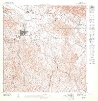
Juncos sits at the heart of this mid-century survey, revealing a landscape defined by the sugar industry and the winding course of the Río Gurabo. The urban grid of the town is closely tied to the Central Juncos sugar mill and the Eastern Sugar Associates transportation infrastructure, which dominated the local economy during the 1940s. The surrounding rural areas include the settlements of Cantagallo and El Mango, connected by a network of watercourses like Valenciano and Quebrada Doña Ana. The map captures the transition between the developed valley floor and the rising terrain where Algodón is situated, marking the municipal boundaries where Juncos meets Las Piedras and San Lorenzo. This document is a primary record of Puerto Rico's agricultural period before the island's rapid industrialization in the later 20th century.
Find a feature on this map
12 named features on this map. Tap any name to fly to it.
Don’t see what you’re looking for? This feature index may not catch every label — zoom into the map to look around manually.
Map Details
Editions of this 1947 Juncos NE Map
This is the sole edition of this map. No revisions or reprints were ever made.
Historical Maps of Urbanización Colinas de Juncos Through Time
1 maps found
Featured Locations
- La Placita, Juncos
- Sector Collazo II, Juncos
- Urbanización Colinas de Juncos, Juncos
- Juncos, Juncos
- Sector Carmita Torres, Las Piedras