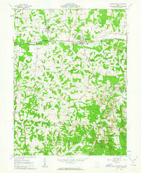
1961 Map of Junction City
USGS Topo · Published 1963About this map
Junction City serves as the industrial and transit hub of this 1961 survey, where the New York Central and Pennsylvania rail lines intersect. The landscape is heavily marked by the region's extraction history, featuring numerous oil wells and a strip mine near the town center. Of particular historical note is the Ohio State Penitentiary Junction City Branch, located along the Baltimore and Ohio line northwest of the main settlement. The southern portion of the map transitions into the Wayne National Forest Boundary, following the rugged drainage of Monday Creek and Turkey Run. Local genealogy is well-preserved through several rural landmarks, including the Old Zion Ch Cem and Friendship Ch, which anchored the scattered communities of Carthon, Salem, and Crossenville during the mid-century era.
Find a feature on this map
39 named features on this map. Tap any name to fly to it.
Don’t see what you’re looking for? This feature index may not catch every label — zoom into the map to look around manually.
Map Details
Editions of this 1961 Junction City Map
Other maps of this area

1907 · Logan
USGS Topo · 1:62,500

1909 · Thornville
USGS Topo · 1:62,500

1909 · Logan
USGS Topo · 1:62,500

1910 · Zanesville
USGS Topo · 1:62,500

1911 · New Lexington
USGS Topo · 1:62,500

1947 · Columbus
USGS Topo · 1:250,000

1961 · Columbus
USGS Topo · 1:250,000

1961 · Rushville
USGS Topo · 1:24,000

1961 · New Lexington
USGS Topo · 1:24,000
1961 · New Straitsville
USGS Topo · 1:24,000