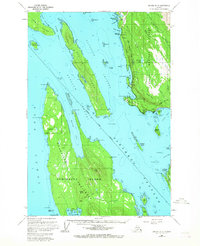
1962 Map of Juneau B-3
USGS Topo · Published 1967About this map
Stephens Passage and Saginaw Channel dominate this maritime landscape near the height of mid-century coastal development. The coastal mainland is anchored by the Glacier Highway, which follows the shoreline of Tee Harbor and Lena Cove, connecting recreational landmarks like the Lena Beach Recreation Area and the Auke Recreation Area. Religious and local history is centered at the Shrine of St Terese and nearby Dotsons Landing.
Find a feature on this map
92 named features on this map. Tap any name to fly to it.
Don’t see what you’re looking for? This feature index may not catch every label — zoom into the map to look around manually.
Map Details
Editions of this 1962 Juneau B-3 Map
2 editions found

Other maps of this area

1947 · Juneau B-3
USGS Topo · 1:63,360

1947 · Juneau B-2
USGS Topo · 1:63,360

1948 · Juneau B-4
USGS Topo · 1:63,360

1948 · Juneau A-3
USGS Topo · 1:63,360

1948 · Juneau C-4
USGS Topo · 1:63,360

1948 · Juneau A-4
USGS Topo · 1:63,360

1949 · Juneau B-3
USGS Topo · 1:62,500

1949 · Juneau B-2
USGS Topo · 1:62,500

1949 · Juneau C-4
USGS Topo · 1:63,360

1949 · Juneau B-4
USGS Topo · 1:63,360