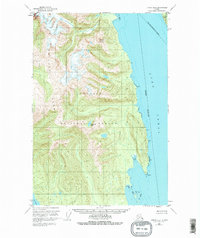
1949 Map of Juneau B-4
USGS Topo · Published 1974About this map
The Chilkat Range dominates this mid-century survey of the wilderness northwest of Juneau, where steep peaks drop sharply into the waters of the Lynn Canal. This 1949 edition captures a landscape defined by dramatic elevation changes and significant federal land designations, split between the Tongass National Forest and the Glacier Bay National Monument. The map reflects a period before modern road infrastructure, emphasizing the maritime and topographical landmarks essential for navigation in Southeast Alaska. Coastal features such as Pt Howard and the Tidal Flat along the eastern shore are detailed alongside inland water bodies like the high-elevation Teardrop Lake. On the northeastern edge, Lincoln Island sits isolated in the canal, while the Lynn Sisters name a group of coastal features near Mount Golub, providing reference points in an area primarily accessible by sea via the Icy Strait.
Find a feature on this map
13 named features on this map. Tap any name to fly to it.
Don’t see what you’re looking for? This feature index may not catch every label — zoom into the map to look around manually.
Map Details
Editions of this 1949 Juneau B-4 Map
2 editions found
Other maps of this area

1947 · Juneau B-3
USGS Topo · 1:63,360

1948 · Juneau C-5
USGS Topo · 1:63,360

1948 · Juneau B-4
USGS Topo · 1:63,360

1948 · Juneau A-3
USGS Topo · 1:63,360

1948 · Juneau C-4
USGS Topo · 1:63,360

1948 · Juneau A-4
USGS Topo · 1:63,360

1948 · Juneau B-5
USGS Topo · 1:63,360

1949 · Juneau B-3
USGS Topo · 1:62,500

1949 · Juneau C-4
USGS Topo · 1:63,360

1949 · Juneau B-4
USGS Topo · 1:63,360