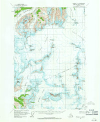
1960 Map of Juneau C-2
USGS Topo · Published 1971About this map
Tongass National Forest encompasses this high-altitude glacial landscape northeast of Juneau, where a massive network of ice fields and towering peaks defines the terrain. The sheet provides an intensive study of the area's ice-flow patterns, capturing the massive Taku Glacier and its West Branch, alongside the Mendenhall Glacier and Herbert Glacier.
Find a feature on this map
36 named features on this map. Tap any name to fly to it.
Don’t see what you’re looking for? This feature index may not catch every label — zoom into the map to look around manually.
Map Details
Editions of this 1960 Juneau C-2 Map
2 editions found

Other maps of this area

1947 · Juneau B-3
USGS Topo · 1:63,360

1947 · Juneau B-2
USGS Topo · 1:63,360

1948 · Juneau D-3
USGS Topo · 1:63,360

1948 · Juneau B-1
USGS Topo · 1:63,360

1949 · Juneau B-3
USGS Topo · 1:62,500

1949 · Juneau B-2
USGS Topo · 1:62,500

1949 · Juneau D-3
USGS Topo · 1:63,360

1951 · Juneau
USGS Topo · 1:250,000

1951 · Juneau C-3
USGS Topo · 1:63,360

1952 · Juneau B-1
USGS Topo · 1:63,360