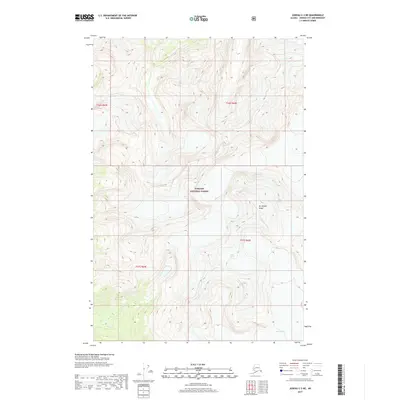
2017 Map of Juneau C-3 NE
USGS Topo · Published 2017About this map
Tongass National Forest dominates this northern Alaskan landscape, where the movement of ice and water across extreme elevations is clearly visible. The survey focuses on a remote sector of the Juneau City and Borough, centered on the massive Eagle Glacier and the adjacent Thiel Glacier. These frozen expanses are separated by high ridges, including the prominent summit of Mt Adolph Knopf. The drainage patterns are defined by the glacial melt, feeding systems like Coulee Cr and Canyon Cr as they cut through the steep topography. This document provides a precise record of glacial positions and water flow within the national forest at the time of the 2017 survey, useful for tracking changes in the ice field and its surrounding alpine environment.
Find a feature on this map
10 named features on this map. Tap any name to fly to it.
Don’t see what you’re looking for? This feature index may not catch every label — zoom into the map to look around manually.
Map Details
Editions of this 2017 Juneau C-3 NE Map
This is the sole edition of this map. No revisions or reprints were ever made.
Other maps of this area

1948 · Juneau D-3
USGS Topo · 1:63,360

1949 · Juneau D-3
USGS Topo · 1:63,360

1951 · Juneau
USGS Topo · 1:250,000

1951 · Juneau C-3
USGS Topo · 1:63,360

1952 · Juneau C-3
USGS Topo · 1:63,360

1953 · Juneau D-3
USGS Topo · 1:63,360

1960 · Juneau C-2
USGS Topo · 1:63,360

1960 · Juneau D-2
USGS Topo · 1:63,360

1962 · Juneau
USGS Topo · 1:250,000
1986 · Juneau C-3 SW
USGS Topo · 1:25,000