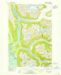
1953 Map of Juneau D-3
USGS Topo · Published 1954About this map
Berners Bay serves as the terminal point for a massive glacial drainage system in Southeast Alaska, as documented in this 1953 topographic study. The landscape is defined by the heavy braiding of the Lace River, Berners River, and Antler River, which deposit silt into the broad Mud flats at the head of the bay. These glacial rivers carve through the protected lands of the Tongass National Forest, creating a complex network of shifting channels and islands. While the area is largely characterized by this dynamic hydrology, a single Cabin appears near the western shore of the bay, marking a rare point of human infrastructure in an otherwise remote wilderness. The 1953 aerial photography captures the extent of the ice fields and the precise boundaries of the national forest before later 20th-century shifts in the glacial and forest environment.
Find a feature on this map
8 named features on this map. Tap any name to fly to it.
Don’t see what you’re looking for? This feature index may not catch every label — zoom into the map to look around manually.
Map Details
Editions of this 1953 Juneau D-3 Map
2 editions found

Other maps of this area

1948 · Juneau C-4
USGS Topo · 1:63,360

1948 · Juneau D-3
USGS Topo · 1:63,360

1948 · Skagway A-1
USGS Topo · 1:63,360

1949 · Atlin
USGS Topo · 1:250,000

1949 · Juneau D-4
USGS Topo · 1:63,360

1949 · Juneau C-4
USGS Topo · 1:63,360

1949 · Juneau D-3
USGS Topo · 1:63,360

1951 · Juneau
USGS Topo · 1:250,000

1951 · Skagway A-1
USGS Topo · 1:63,360

1951 · Atlin
USGS Topo · 1:250,000