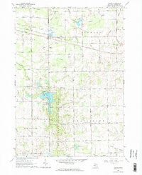
1963 Map of Juniata
USGS Topo · Published 1964About this map
Murphy Lake State Game Area dominates the central landscape of this early 1960s survey, illustrating a region defined by its complex drainage network and early industrial extraction. Numerous Sandpits and Gravel Pits are scattered across the townships of Vassar, Fremont, and Watertown, following the glacial deposits that shaped this part of the Thumb. The Chesapeake and Ohio railroad provides a primary east-west corridor through the hamlet of Juniata, linking the rural landscape to broader markets.
Find a feature on this map
44 named features on this map. Tap any name to fly to it.
Don’t see what you’re looking for? This feature index may not catch every label — zoom into the map to look around manually.
Map Details
Editions of this 1963 Juniata Map
2 editions found

Other maps of this area

1920 · Flint
USGS Topo · 1:62,500

1922 · Flint
USGS Topo · 1:62,500

1943 · Flint
USGS Topo · 1:62,500

1954 · Flint
USGS Topo · 1:250,000

1958 · Flint
USGS Topo · 1:250,000

1963 · East Dayton
USGS Topo · 1:24,000

1963 · Mayville
USGS Topo · 1:24,000

1963 · Columbiaville
USGS Topo · 1:24,000

1963 · Gilford
USGS Topo · 1:24,000

1963 · Caro
USGS Topo · 1:24,000