
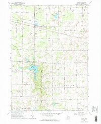
1963 Map of Juniata
USGS Topo · Published 1964About this map
The Chesapeake and Ohio railroad corridor cuts a diagonal path across the northern half of this landscape, passing through the small community of Juniata. The region is defined by an extensive system of agricultural drainage and small waterways, including Taylor Drain, Evergreen Creek, and Krueger Drain, which supported the local farming economy in the early 1960s. To the south, the Murphy Lake State Game Area preserves a significant portion of natural terrain centered around Murphy Lake, offering a sharp contrast to the surrounding grid of rural roads and scattered extraction sites. Numerous sandpits and gravel pits are mapped throughout Fremont and Vassar townships, indicating the importance of aggregate mining to the area's development. Local education and community life are anchored at the Watertown Center Sch within Watertown township, while family-named routes like Waltan Road and Leix Road reflect the deeply rooted history of this rural Michigan territory.
Find a feature on this map
49 named features on this map. Tap any name to fly to it.
Don’t see what you’re looking for? This feature index may not catch every label — zoom into the map to look around manually.
Map Details
Editions of this 1963 Juniata Map
2 editions found
Other maps of this area

1920 · Flint
USGS Topo · 1:62,500

1922 · Flint
USGS Topo · 1:62,500

1943 · Flint
USGS Topo · 1:62,500

1954 · Flint
USGS Topo · 1:250,000

1958 · Flint
USGS Topo · 1:250,000

1963 · East Dayton
USGS Topo · 1:24,000

1963 · Mayville
USGS Topo · 1:24,000

1963 · Columbiaville
USGS Topo · 1:24,000

1963 · Gilford
USGS Topo · 1:24,000

1963 · Caro
USGS Topo · 1:24,000
Featured Places
- Juniata, Vassar Township
- Vassar Township, MI
- Millington Township, MI
- Watertown Township, MI
- Fremont Township, MI