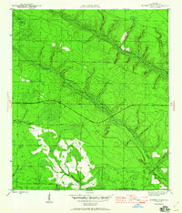
1945 Map of Juniper Creek
USGS Topo · Published 1960About this map
Juniper Creek and its many winding tributaries dominate this Calhoun County landscape, as mapped just before the end of the second World War. The area is characterized by an intricate network of waterways and wetlands, including Buzzards Bay Swamp and Big Bear Bay, which suggest a terrain largely defined by drainage and seasonally wet lowlands. Human activity is marked by established routes like the C C C Road, reflecting the infrastructure projects of the preceding decade, and the Kingstown Road running through the southern section.
Find a feature on this map
29 named features on this map. Tap any name to fly to it.
Don’t see what you’re looking for? This feature index may not catch every label — zoom into the map to look around manually.
Map Details
Editions of this 1945 Juniper Creek Map
3 editions found
Other maps of this area

1944 · Clarksville
USGS Topo · 1:31,680

1945 · Juniper Creek
USGS Topo · 1:31,680

1945 · Youngstown
USGS Topo · 1:31,680

1945 · Clarksville
USGS Topo · 1:31,680

1945 · Broad Branch
USGS Topo · 1:31,680

1945 · Frink
USGS Topo · 1:31,680

1945 · Fountain
USGS Topo · 1:31,680

1952 · Alford SE
USGS Topo · 1:24,000

1952 · Altha West
USGS Topo · 1:24,000
1952 · Compass Lake
USGS Topo · 1:24,000