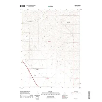
2020 Map of Juniper
USGS Topo · Published 2020About this map
Juniper sits at the intersection of local routes within the high-desert landscape of Oneida County, serving as a focal point for the surrounding Juniper Valley. The terrain is defined by the prominent Sublett Range to the east and a series of dramatic topographical depressions including Saddle Horse Basin and Crazy Canyon.
Find a feature on this map
27 named features on this map. Tap any name to fly to it.
Don’t see what you’re looking for? This feature index may not catch every label — zoom into the map to look around manually.
Map Details
Editions of this 2020 Juniper Map
This is the sole edition of this map. No revisions or reprints were ever made.
Other maps of this area

1954 · Pocatello
USGS Topo · 1:250,000

1958 · Pocatello
USGS Topo · 1:250,000

1958 · Sublett
USGS Topo · 1:62,500

1959 · Strevell
USGS Topo · 1:62,500

1973 · Juniper
USGS Topo · 1:24,000

1973 · The Cove
USGS Topo · 1:24,000

1973 · Sublett Troughs
USGS Topo · 1:24,000
1973 · Roy
USGS Topo · 1:24,000

1973 · Black Pine
USGS Topo · 1:24,000
1973 · Badger Hole Spring
USGS Topo · 1:24,000