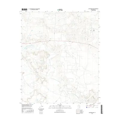
2016 Map of Justiceburg NW
USGS Topo · Published 2016About this map
The winding N Fork Double Mountain Fork Brazos River carves through the central terrain of this Garza County landscape, providing a stark hydrological contrast to the surrounding ranchlands. The area is defined by an extensive network of named stock tanks, a critical component of the local cattle-raising economy. Landmarks such as Giles Tank, Twin Sisters Tanks, and Skull Tank dot the topography, indicating historical water management patterns. In the northeast, the Beach Ranch Airport sits near Slicknasty Cr, highlighting the intersection of modern aviation and traditional land use. Primary transit is facilitated by US Route 380 and FM 2008, which connect these remote agricultural outposts to the wider region. The map captures a detailed view of the drainage systems and seasonal creeks, including Sand Cr, that feed into the larger Brazos River system.
Find a feature on this map
22 named features on this map. Tap any name to fly to it.
Don’t see what you’re looking for? This feature index may not catch every label — zoom into the map to look around manually.
Map Details
Editions of this 2016 Justiceburg NW Map
This is the sole edition of this map. No revisions or reprints were ever made.
Other maps of this area

1954 · Lubbock
USGS Topo · 1:250,000

1962 · Twomile Creek
USGS Topo · 1:24,000

1969 · Verbena
USGS Topo · 1:24,000

1969 · Cap Rock SE
USGS Topo · 1:24,000

1969 · Cottonwood Creek
USGS Topo · 1:24,000

1969 · Justiceburg SE
USGS Topo · 1:24,000
1969 · Justiceburg NW
USGS Topo · 1:24,000

1969 · Post East
USGS Topo · 1:24,000

1969 · Justiceburg
USGS Topo · 1:24,000

1969 · Cooper Creek
USGS Topo · 1:24,000