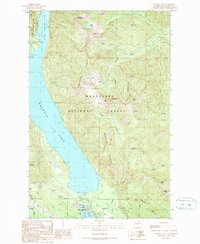
1989 Map of Kachess Lake
USGS Topo · Published 1989About this map
Kachess Lake and its smaller counterpart, Little Kachess Lake, dominate this mountain corridor of the Cascades as they appeared in the late 1980s. Managed water levels are evident at the Kachess Dam and its associated Intake and Gaging Station, which regulate the flow into the Kachess River. The landscape is a mix of high-elevation peaks including Thorp Mountain and Amabilis Mountain, all contained within the Wenatchee National Forest.
Find a feature on this map
44 named features on this map. Tap any name to fly to it.
Don’t see what you’re looking for? This feature index may not catch every label — zoom into the map to look around manually.
Map Details
Editions of this 1989 Kachess Lake Map
2 editions found
Other maps of this area

1901 · Snoqualmie Pass
USGS Topo · 1:125,000

1903 · Snoqualmie
USGS Topo · 1:125,000

1957 · Wenatchee
USGS Topo · 1:250,000

1961 · Snoqualmie Pass
USGS Topo · 1:62,500

1961 · Easton
USGS Topo · 1:62,500

1961 · Kachess Lake
USGS Topo · 1:62,500

1962 · Lester
USGS Topo · 1:62,500

1975 · Snoqualmie Pass
USGS Topo · 1:100,000

1989 · Easton
USGS Topo · 1:24,000
1989 · Ronald
USGS Topo · 1:24,000