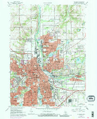
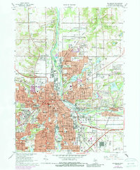
1967 Map of Kalamazoo
USGS Topo · Published 1988About this map
The Kalamazoo River carves a deep path through this mid-century landscape, serving as the industrial and geographical spine for the cities of Kalamazoo and Parchment. During this era, the expansion of the urban core is evident in purple revisions, reaching toward Eastwood and the residential blocks of Milwood. The map captures a high density of institutional landmarks, from the sprawling campus of Western Michigan University and Nazareth College to the Kalamazoo State Hospital. Genealogists will find a wealth of burial records across sites like Mountain Home Cem and the extensive Mt Ever-Rest Memorial Park. Transport is dominated by the Penn Central rail lines and the developing highway system, including Interchange 81. Beyond the city limits, the landscape transitions to the marshy edges of Kleinstuck Marsh and the educational grounds of the Kalamazoo Nature Center.
Find a feature on this map
88 named features on this map. Tap any name to fly to it.
Don’t see what you’re looking for? This feature index may not catch every label — zoom into the map to look around manually.
Map Details
Editions of this 1967 Kalamazoo Map
5 editions found
Other maps of this area

1916 · Kalamazoo
USGS Topo · 1:62,500

1918 · Kalamazoo
USGS Topo · 1:62,500

1918 · Galesburg
USGS Topo · 1:62,500

1918 · Leonidas
USGS Topo · 1:62,500

1922 · Schoolcraft
USGS Topo · 1:62,500

1943 · Kalamazoo
USGS Topo · 1:62,500

1943 · Schoolcraft
USGS Topo · 1:62,500

1944 · Leonidas
USGS Topo · 1:62,500

1944 · Galesburg
USGS Topo · 1:62,500

1947 · Delton
USGS Topo · 1:24,000
Featured Places
- Kalamazoo, MI
- Parchment, MI
- Comstock Charter Township, MI
- Kalamazoo Charter Township, MI
- Richland Township, MI