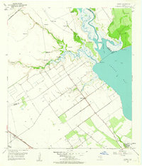
1952 Map of Kamey
USGS Topo · Published 1963About this map
The coastal plains of the Texas Gulf Coast are defined here by a network of bayous and drainage systems that feed into Lavaca Bay and Garcitas Cove. During the early 1950s, this landscape was characterized by a heavy reliance on hydraulic infrastructure, with numerous Levee systems and an abundance of Flowing Wells dotting the terrain near Placedo Creek and Aguila Creek. The small community of Kamey sits at a rail junction where the Southern Pacific and Missouri Pacific lines converge, serving as a transit point for the region's emerging energy and agricultural sectors. Further east, local life centered around the Sixmile Sch and Sixmile Ch, while the southern expanse of the quadrangle shows the early development of a significant Gas Field. This survey captures the transition from traditional ranching and farming to an industrializing coast, marked by extensive gas wells and strategic shoreline points like Keeran Point.
Find a feature on this map
27 named features on this map. Tap any name to fly to it.
Don’t see what you’re looking for? This feature index may not catch every label — zoom into the map to look around manually.
Map Details
Editions of this 1952 Kamey Map
Other maps of this area

1952 · Port Lavaca East
USGS Topo · 1:24,000

1952 · Point Comfort
USGS Topo · 1:24,000

1952 · Kamey
USGS Topo · 1:24,000

1952 · Port Lavaca West
USGS Topo · 1:24,000

1952 · La Salle
USGS Topo · 1:24,000

1952 · Marcado Creek
USGS Topo · 1:24,000

1952 · Placedo
USGS Topo · 1:24,000

1952 · Lolita
USGS Topo · 1:24,000

1952 · Green Lake
USGS Topo · 1:24,000

1953 · Beeville
USGS Topo · 1:250,000